Mapping Tools
Feature Index
Tools Index
 | Map Channels v9 Beta
URL: https://mc9.mapchannels.com/
Map Channels v9 Beta is a simple mapping tool which includes an integrated editor.
• Simple streamlined design.
• Import KML and Google My Map data.
• Create custom map marker categories.
• Display Google Street View.
• Display website banners.
• Embed map and share map links.
• Custom project development available - contact for details.
|
 | Animated Route Maps
URL: https://www.mapchannels.com/AnimatedRouteMaps.aspx
Route Maps display a set of directions as a route map with animated street view.
• Display Google Street View, 3D Maps or Birds Eye imagery for any point along the route.
• Watch an animation of all or part of the journey.
• Many options available to customize the map.
• Simple to embed the map on your web page, no registration is required.
• Easy to share and edit routes.
|
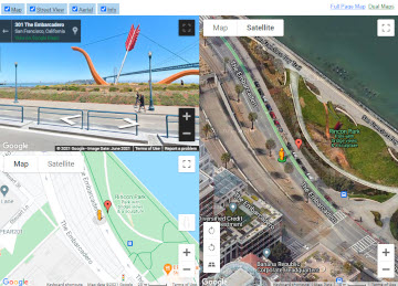 | Dual Maps
URL: https://www.mapchannels.com/DualMaps.aspx
Dual Maps combine Google Maps, Google Street View and Birds Eye imagery into one embeddable control.
• Many customization options are available.
• Include an address search box.
• Supply either a latitude/longitude coordinate or a place address as a parameter.
• Free to use, no registration is required.
• See also Team Maps which can display multiple locations using a similar interface.
|
 | Video Maps
URL: https://www.mapchannels.com/VideoMaps.aspx
Video maps display a YouTube video alongside a route map. A marker indicates the currently viewed location on the route map.
• Click on any point along the route to view the imagery for that location.
• Optional display of street view and a route elevation chart.
• A separate version using the Leaflet Maps API is available.
• See also Team Maps which can display multiple routes with synchronized YouTube video or animated street view.
|
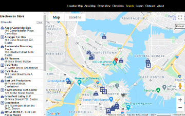
 | Team Maps
URL: https://www.mapchannels.com/TeamMaps.aspx
Team Maps combine and display multiple feeds of data. Locations can be displayed using a combination of maps, birds eye view and street view.
• Multiple resizeable panels including two Google maps, Google Street View, YouTube video, index panel and profile panel.
• KML, Text and GPX format feeds are supported.
• Import data from other Map Channels projects (e.g. Map Channels v8).
• View routes using animated streetview or with synchronized YouTube video.
• Clustering option to display large number of markers.
• Add filters (name, category and value) to view a subset of places.
• An extensive range of options are available to customize your Team Map.
|
 | Geocoder
URL: https://www.mapchannels.com/Geocoder.aspx
Use the Geocoder to find latitude and longitude coordinates for a given address.
Links to single location maps are automatically generated by the Geocoder.
The Integration Guide provides examples and tutorials to assist with adding the maps to web pages.
See the Geocoding Resources page for links to external geocoding and routing services. |
 | Local Maps
URL: https://www.mapchannels.com/LocalMaps.aspx
Local Maps provide a simple way to create a map displaying a single place marker.
Options include:
• Google Street View.
• Driving, bicycling and walking directions.
• Google Places Search.
• Show map layers including traffic, bicycling and public transit.
• Distance Tools to measure distances between points or display a radius circle around the place.
|
 | Street Tours
URL: https://www.mapchannels.com/StreetTours.aspx
Street Tours combine Google Street View and Maps to display an interactive tour.
Street Tours can display mutiple outdoor or indoor locations.
Clickable labels can be displayed within the street view panorama to provide additional information for the user.
|
 | Quad View Maps
URL: https://www.mapchannels.com/QuadViewMaps.aspx
Quad View Maps display a set of synchronized maps plus street view that let you view a location from multiple angles.
• When the 'Map x4' option is selected four separate maps are displayed in birds eye mode, each facing in a different direction.
• When street view is enabled a pegman marker is displayed on each map. The pegman marker on the first map can be dragged and dropped to change the current street view position.
• Use the address search text box to view different locations.
• Free to use, no registration is required.
|
 | Autocomplete Maps
URL: https://www.mapchannels.com/AutocompleteMaps.aspx
Autocomplete Maps are a way to display Google Search Autocomplete results for a collection of places on a map.
Although the results are not necessarily scientific or correct they can be quite informative and/or entertaining.
Clicking the labels will display a list of all the Autocomplete results that were obtained.
You can create and manage your Autocomplete Maps using the dashboard.
A range of options let you select the search terms and display format for your map.
|
 | API Key Reference
URL: https://www.mapchannels.com/APIKey.aspx
The API Key Reference provides a guide to creating and managing API keys for use with the Google Maps API.
An API key is not required for most Map Channels tools.
Some maps which can be locally hosted on your own website do need an API key.
|
 | My Maps Plus
URL: https://www.mymapsplus.com/
My Maps Plus is the forerunner site of Map Channels, created in 2007. The original My Maps Plus mapping tool allowed users to create embeddable maps using data from Google My Maps.
User registration is now closed for My Maps Plus. Updated versions of the original mapping tools are now available through Map Channels.
. |
 | See Bournemouth
URL: https://www.seebournemouth.com/
See Bournemouth is a local tourism guide to Bournemouth, a coastal resort town in England.
The site was set up in 2006 and was the starting point for developing server-side and mapping code that was later used within Map Channels websites.
The current version of See Bournemouth uses an adapted version of the Team Maps tool to display maps, street view and placemarks.
The map also includes imagery from an historic 1897 street map and an Ordnance Survey map from 1931.
|
|
|